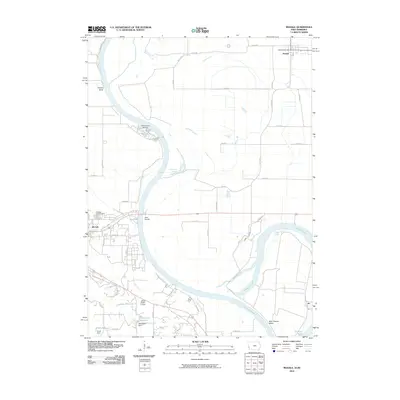
2010 Map of Modale
USGS Topo · Published 2010About this map
Blair, Nebraska, and Modale, Iowa, sit on opposite sides of a complex riverine landscape defined by the shifting course of the Missouri River. This 2010 survey highlights the intricate hydrology of the valley, where former channels and bends have transitioned into landmarks like the California Cutoff, De Soto Lake, and the De Soto Cutoff. On the Nebraska side, the outskirts of Blair include the Blair Cemetery and several water management features such as the Henricksen Dam and Wrich Dam which create the Henricksen Reservoir and Wrich Reservoir respectively. To the northeast, the small community of Modale is anchored by the Modale Post Office. The map also captures local recreational and institutional sites, including the Cottonwood Marina, Rand Access, and the Christ Child Camp, illustrating how the floodplains of Fish Creek and Long Creek are utilized for both community services and water control.
Find a feature on this map
51 named features on this map. Tap any name to fly to it.
Don’t see what you’re looking for? This feature index may not catch every label — zoom into the map to look around manually.
Map Details
Editions of this 2010 Modale Map
This is the sole edition of this map. No revisions or reprints were ever made.
Other maps of this area

1893 · Omaha
USGS Topo · 1:62,500

1893 · Fremont
USGS Topo · 1:125,000

1896 · Fremont
USGS Topo · 1:125,000

1954 · Omaha
USGS Topo · 1:250,000

1955 · Fremont
USGS Topo · 1:250,000

1957 · Fremont
USGS Topo · 1:250,000

1957 · Omaha
USGS Topo · 1:250,000

1957 · Loveland
USGS Topo · 1:24,000

1958 · Omaha
USGS Topo · 1:250,000

1958 · Fremont
USGS Topo · 1:250,000