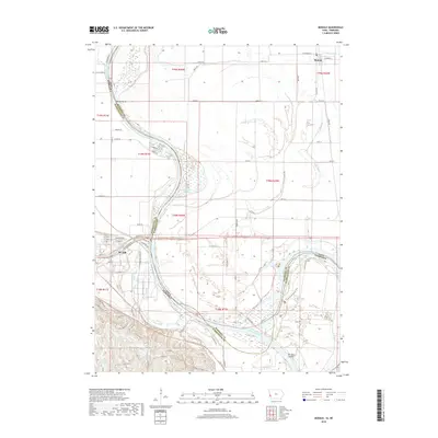
2018 Map of Modale
USGS Topo · Published 2018About this map
Blair and Modale anchor this Missouri River landscape, illustrating the complex hydrology of the Iowa-Nebraska border. The river's historical path is traced through several distinct water bodies and oxbow-related features, such as the California Cutoff, De Soto Lake, and De Soto Cutoff. These features reveal the shifting nature of the river channel over time, creating a mosaic of wetlands and agricultural lands. North of Blair, the Blair Cem and the industrial layout along Industrial Park Dr provide points of interest for genealogists and local historians. The map also captures the intricate drainage system necessary for this floodplain, including the Modale Ditch, Youngs Ditch, and Cameron Ditch. Smaller reservoirs like Jensen Reservoir and Wrich Reservoir dot the southwestern corner, further emphasizing the importance of water management in this riverine environment.
Find a feature on this map
76 named features on this map. Tap any name to fly to it.
Don’t see what you’re looking for? This feature index may not catch every label — zoom into the map to look around manually.
Map Details
Editions of this 2018 Modale Map
This is the sole edition of this map. No revisions or reprints were ever made.
Other maps of this area

1893 · Omaha
USGS Topo · 1:62,500

1893 · Fremont
USGS Topo · 1:125,000

1896 · Fremont
USGS Topo · 1:125,000

1954 · Omaha
USGS Topo · 1:250,000

1955 · Fremont
USGS Topo · 1:250,000

1957 · Fremont
USGS Topo · 1:250,000

1957 · Omaha
USGS Topo · 1:250,000

1957 · Loveland
USGS Topo · 1:24,000

1958 · Omaha
USGS Topo · 1:250,000

1958 · Fremont
USGS Topo · 1:250,000