
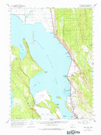
1957 Map of Modoc Point
USGS Topo · Published 1966About this map
Klamath Indian Reservation territory dominates the eastern portion of this landscape, where the Southern Pacific tracks run a tight corridor between the shoreline and the rising Chiloquin Ridge. Along the eastern edge of Upper Klamath Lake, several small settlements and industrial markers appear, including the timber-history site of the Algoma Incline (Site) near Algoma. The geography is defined by a series of reclaimed marshes and natural springs, such as Caledonia Marsh and Barkley Spring, illustrating the complex water management required in this lake-basin environment.
Find a feature on this map
66 named features on this map. Tap any name to fly to it.
Don’t see what you’re looking for? This feature index may not catch every label — zoom into the map to look around manually.
Map Details
Editions of this 1957 Modoc Point Map
2 editions found
Other maps of this area

1889 · Klamath
USGS Topo · 1:250,000

1891 · Ashland
USGS Topo · 1:250,000

1893 · Ashland
USGS Topo · 1:250,000

1894 · Klamath
USGS Topo · 1:250,000

1897 · Ashland
USGS Topo · 1:250,000

1955 · Lake O' Woods
USGS Topo · 1:62,500

1955 · Surveyor Mtn
USGS Topo · 1:62,500

1955 · Pelican Butte
USGS Topo · 1:62,500

1955 · Klamath Falls
USGS Topo · 1:250,000

1955 · Medford
USGS Topo · 1:250,000