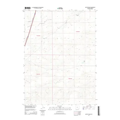
2015 Map of Moffett Ranch
USGS Topo · Published 2015About this map
Moffett Ranch and its namesake landscape anchor this Laramie County survey, illustrating the persistence of ranching operations in southeastern Wyoming. The terrain is defined by the east-flowing drainage systems of N Bear Cr and Little Bear Cr, which dictate the placement of local infrastructure and private airstrips like Vowers Ranch Airport. The map highlights a network of county thoroughfares and service routes, including Bear Creek Rd and Wilkerson Rd, which provide access across the township lines of T19N and T18N. While Interstate 25 skirts the western edge via the I-25 Service Rd, the interior remains a quiet expanse of rangeland where cattle operations and small rural facilities represent the primary human imprint on the land.
Find a feature on this map
14 named features on this map. Tap any name to fly to it.
Don’t see what you’re looking for? This feature index may not catch every label — zoom into the map to look around manually.
Map Details
Editions of this 2015 Moffett Ranch Map
This is the sole edition of this map. No revisions or reprints were ever made.
Other maps of this area

1911 · Cheyenne
USGS Topo · 1:125,000

1914 · Cheyenne
USGS Topo · 1:125,000

1954 · Cheyenne
USGS Topo · 1:250,000

1958 · Cheyenne
USGS Topo · 1:250,000

1962 · Moffett Ranch
USGS Topo · 1:24,000

1962 · Lewis Ranch
USGS Topo · 1:24,000

1962 · Bristol Ridge
USGS Topo · 1:24,000
1962 · Nimmo Ranch
USGS Topo · 1:24,000

1962 · Bristol Ridge NE
USGS Topo · 1:24,000
1962 · Whitcomb Hill
USGS Topo · 1:24,000