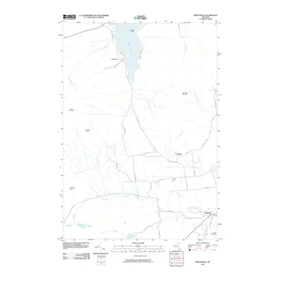
2010 Map of Moffitsville
USGS Topo · Published 2010About this map
Adirondack Park boundaries encompass this portion of Clinton County, where the settlement of Chazy Lake sits on the western shore of its namesake water body. The landscape is defined by its significant drainage systems, with the Saranac River cutting through the southeast corner near Moffitsville and the winding course of True Brook moving across the central valley. To the west, the massif of Lyon Mountain and the distinct peak of Brushy Knob dominate the high ground. The map records the historical footprint of the region's transportation history, specifically marking the Old Rail Road Bed passing through the hamlet of Russia. This corridor reflects the 19th-century industrial efforts to move timber and iron ore through the northern forest. From the northern reaches of Seine Bay to the southern elevations of Russia Mountain, the geography illustrates a transition from lakefront habitation to dense, mountain-ringed woodlands.
Find a feature on this map
44 named features on this map. Tap any name to fly to it.
Don’t see what you’re looking for? This feature index may not catch every label — zoom into the map to look around manually.
Map Details
Editions of this 2010 Moffitsville Map
This is the sole edition of this map. No revisions or reprints were ever made.
Other maps of this area

1895 · Mooers
USGS Topo · 1:62,500

1899 · Mooers
USGS Topo · 1:62,500

1911 · Lyon Mountain
USGS Topo · 1:62,500

1913 · Dannemora
USGS Topo · 1:62,500

1913 · Lyon Mountain
USGS Topo · 1:62,500

1915 · Churubusco
USGS Topo · 1:62,500

1931 · Lyon Mountain
USGS Topo · 1:62,500

1942 · Mooers
USGS Topo · 1:62,500

1943 · Churubusco
USGS Topo · 1:62,500

1943 · Mooers
USGS Topo · 1:62,500