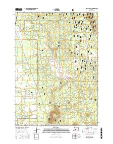
2017 Map of Moffitt Butte
USGS Topo · Published 2017About this map
Moffitt Butte and the flanks of Newberry Volcano dominate this high-desert landscape in central Oregon. Much of the terrain is managed as part of the Deschutes National Forest, where a network of Forest Service roads, including Moffitt Butte Rd and Nat For Dev Rd 100, provides access to the volcanic topography. The map illustrates a clear transition between public timberlands and growing residential developments in the southwestern portion of the quadrangle. Streets such as Sun Forest Dr, Inglewood Rd, and Split Rail Rd show a modern subdivision pattern carving into the forest edge near the Deschutes and Klamath County line. This 2017 survey documents the intersection of recreational public lands and suburban expansion in a region defined by its volcanic geology.
Find a feature on this map
33 named features on this map. Tap any name to fly to it.
Don’t see what you’re looking for? This feature index may not catch every label — zoom into the map to look around manually.
Map Details
Editions of this 2017 Moffitt Butte Map
This is the sole edition of this map. No revisions or reprints were ever made.
Other maps of this area

1930 · Maiden Peak
USGS Topo · 1:125,000

1931 · Newberry Crater
USGS Topo · 1:125,000

1934 · Maiden Peak
USGS Topo · 1:125,000

1935 · Chemult
USGS Topo · 1:96,000

1935 · Newberry Crater
USGS Topo · 1:125,000

1941 · Chemult
USGS Topo · 1:125,000

1955 · Crescent
USGS Topo · 1:250,000

1957 · Crescent
USGS Topo · 1:250,000

1958 · Crescent
USGS Topo · 1:250,000

1963 · La Pine
USGS Topo · 1:24,000