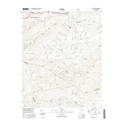
2016 Map of Moffitt Hill
USGS Topo · Published 2016About this map
Old Fort serves as a primary gateway to the high country of the Blue Ridge, situated where the headwaters of the Catawba River and its Left Prong descend from the Pisgah National Forest. The landscape is defined by its deep gaps and prominent peaks, such as Logan Mtn and Flint Knob, which divide the drainages of the Catawba from the Little Toe River to the east. Small settlements and family enclaves are scattered throughout the coves, including Lackey Town, Moffitt Hill, and Davistown. These communities are often anchored by local landmarks like the Davistown Cem and Pine Cove Cem. The road network, including Batcave Rd and Old Fort Sugar Hill Rd, follows the natural contours of the ridges and creek valleys, illustrating the historical reliance on mountain passes like Little Deep Gap and Sank Gap for travel between McDowell, Buncombe, and Rutherford counties.
Find a feature on this map
165 named features on this map. Tap any name to fly to it.
Don’t see what you’re looking for? This feature index may not catch every label — zoom into the map to look around manually.
Map Details
Editions of this 2016 Moffitt Hill Map
This is the sole edition of this map. No revisions or reprints were ever made.
Other maps of this area

1900 · Mount Mitchell
USGS Topo · 1:125,000

1902 · Mount Mitchell
USGS Topo · 1:125,000

1907 · Saluda
USGS Topo · 1:125,000

1934 · Parts Of Old Fort and Montreat
USGS Topo · 1:24,000

1935 · Montreat
USGS Topo · 1:24,000

1935 · Batcave
USGS Topo · 1:24,000

1935 · Black Mountain
USGS Topo · 1:24,000

1941 · Black Mountain
USGS Topo · 1:24,000
1942 · Montreat
USGS Topo · 1:24,000
1943 · Black Mountain
USGS Topo · 1:24,000