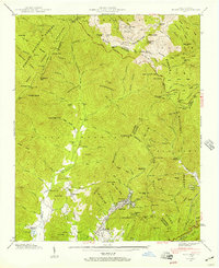
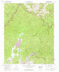
1942 Map of Montreat
USGS Topo · Published 1957About this map
Montreat serves as a focal point in this 1942 landscape, appearing as a developed valley enclave centered around Lake Susan and the Montreat Reservoir. To the west, the settlements of Walkertown and the vicinity of Lake Eden indicate a pattern of rural habitation and institutional land use, supported by local landmarks like Homers Chapel and Mt Zion Ch. The topography is dominated by the steep ridges of the Black Mountains and the winding Blue Ridge Parkway, which traces the high elevations near Craggy Dome and Mt Gibbes. Infrastructure of the era is evidenced by the Southern Railway passing through the Jarrett Tunnel and the presence of a Gaging Station on the North Fork Swannanoa River, reflecting the region's management of water resources and mountain transit prior to mid-century expansions.
Find a feature on this map
117 named features on this map. Tap any name to fly to it.
Don’t see what you’re looking for? This feature index may not catch every label — zoom into the map to look around manually.
Map Details
Editions of this 1942 Montreat Map
5 editions found
Other maps of this area

1900 · Mount Mitchell
USGS Topo · 1:125,000

1902 · Mount Mitchell
USGS Topo · 1:125,000

1934 · Parts Of Celo And Black Brothers
USGS Topo · 1:24,000

1934 · Parts Of Old Fort and Montreat
USGS Topo · 1:24,000

1935 · Montreat
USGS Topo · 1:24,000

1935 · Black Brothers
USGS Topo · 1:24,000

1935 · Black Mountain
USGS Topo · 1:24,000

1935 · Barnardsville
USGS Topo · 1:24,000

1935 · Craggy Pinnacle
USGS Topo · 1:24,000

1941 · Black Mountain
USGS Topo · 1:24,000