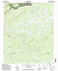
1994 Map of Moffitt Hill
USGS Topo · Published 1998About this map
The Catawba River carves through the northern edge of this landscape, its waters dropping over Catawba Falls within the Pisgah National Forest. This high-altitude terrain at the junction of McDowell, Buncombe, and Rutherford counties is defined by a dense network of ridges and gaps, including Logan Mountain and Wolf Pen Mtn. Settlement is concentrated along the creek valleys, with communities like Old Fort and Davistown serving as focal points for the surrounding rural area.
Find a feature on this map
79 named features on this map. Tap any name to fly to it.
Don’t see what you’re looking for? This feature index may not catch every label — zoom into the map to look around manually.
Map Details
Editions of this 1994 Moffitt Hill Map
This is the sole edition of this map. No revisions or reprints were ever made.
Other maps of this area

1900 · Mount Mitchell
USGS Topo · 1:125,000

1902 · Mount Mitchell
USGS Topo · 1:125,000

1907 · Saluda
USGS Topo · 1:125,000

1934 · Parts Of Old Fort and Montreat
USGS Topo · 1:24,000

1935 · Montreat
USGS Topo · 1:24,000

1935 · Batcave
USGS Topo · 1:24,000

1935 · Black Mountain
USGS Topo · 1:24,000

1941 · Black Mountain
USGS Topo · 1:24,000
1942 · Montreat
USGS Topo · 1:24,000
1943 · Black Mountain
USGS Topo · 1:24,000