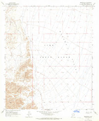
1965 Map of Mohawk SW
USGS Topo · Published 1966About this map
The Copper Mountains dominate the western landscape of this mid-1960s Arizona survey, providing a sharp contrast to the wide expanse of the Mohawk Valley to the east. This section of the Sonoran Desert is largely defined by the boundaries of the Luke Air Force Range, a vast military testing and training area. Despite the arid environment and military designation, the map reveals signs of human activity centered around mineral extraction. Several Mines are scattered through the mountain foothills, including the notably named Betty Lee Mine. Essential water infrastructure for desert survival and operations is represented by the Betty Lee Tank and a Dry Well, while a network of Jeep Trails provides the only recorded access through the steep terrain and sandy washes.
Find a feature on this map
11 named features on this map. Tap any name to fly to it.
Don’t see what you’re looking for? This feature index may not catch every label — zoom into the map to look around manually.
Map Details
Editions of this 1965 Mohawk SW Map
2 editions found
Other maps of this area

1926 · Wellton
USGS Topo · 1:62,500

1926 · Mohawk
USGS Topo · 1:62,500

1928 · Mohawk
USGS Topo · 1:62,500

1929 · Wellton
USGS Topo · 1:62,500

1942 · Yuma
USGS Topo · 1:250,000

1953 · Ajo
USGS Topo · 1:250,000

1954 · El Centro
USGS Topo · 1:250,000

1955 · El Centro
USGS Topo · 1:250,000

1957 · Ajo
USGS Topo · 1:250,000

1958 · Ajo
USGS Topo · 1:250,000