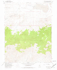
1967 Map of Moho Mountain
USGS Topo · Published 1981About this map
High-altitude desert mining operations define this 1967 survey of Mineral County, where the southern slopes of the Excelsior Mountains and the peak of Moho Mountain meet the arid basins of the Garfield Hills. The landscape is marked by a legacy of extraction, featuring a cluster of named workings including the Birdsong Mine, Silver Gulch Mine, Badger Mine, and Black Hawk Mine. A more extensive complex, the Marietta Mines, occupies the southwestern corner, while the isolated Moho Mine sits on the eastern flank of its namesake mountain.
Find a feature on this map
21 named features on this map. Tap any name to fly to it.
Don’t see what you’re looking for? This feature index may not catch every label — zoom into the map to look around manually.
Map Details
Editions of this 1967 Moho Mountain Map
3 editions found
Other maps of this area

1909 · Hawthorne
USGS Topo · 1:250,000

1911 · Hawthorne
USGS Topo · 1:250,000

1915 · Hawthorne
USGS Topo · 1:250,000

1948 · Walker Lake
USGS Topo · 1:250,000

1957 · Walker Lake
USGS Topo · 1:250,000

1962 · Walker Lake
USGS Topo · 1:250,000

1964 · Walker Lake
USGS Topo · 1:250,000

1967 · Pamlico
USGS Topo · 1:24,000

1967 · Moho Mountain
USGS Topo · 1:24,000

1967 · Mina NW
USGS Topo · 1:24,000