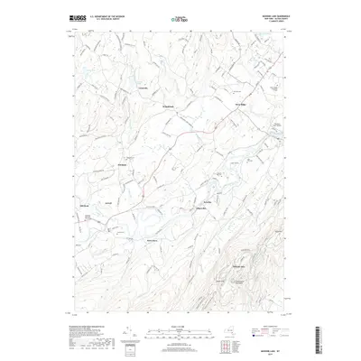
2019 Map of Mohonk Lake
USGS Topo · Published 2019About this map
Rondout Creek and its many tributaries, including the Stony Kill, Sanders Kill, and Rochester Cr, define the valley floor in this region of Ulster County. The landscape is characterized by a series of long-established hamlets like Kripplebush, Stone Ridge, and Accord, which are connected by historic routes such as Old Kings Hwy and the remnants of The Tow Path. This 2019 survey documents the transition from the agricultural lowlands near Sheeley's Farm Airport to the dramatic elevations of the Shawangunk Mountains. At the southern edge, the terrain rises sharply toward Eagle Cliff and Mohonk Lake, where specialized paths like the Overcliff Carriage Trail and Undercliff Carriage Trail navigate the steep slopes. Local history is well-preserved in the numerous burial grounds, such as the Rochester Reformed Church Cem and the High Falls Cem, providing a detailed record of the area's families and community centers.
Find a feature on this map
51 named features on this map. Tap any name to fly to it.
Don’t see what you’re looking for? This feature index may not catch every label — zoom into the map to look around manually.
Map Details
Editions of this 2019 Mohonk Lake Map
This is the sole edition of this map. No revisions or reprints were ever made.
Other maps of this area

1901 · Rosendale
USGS Topo · 1:62,500

1903 · Newburg
USGS Topo · 1:62,500

1903 · Rosendale
USGS Topo · 1:62,500

1903 · Slide Mountain
USGS Topo · 1:62,500

1904 · Ellenville
USGS Topo · 1:62,500

1905 · Slide Mountain
USGS Topo · 1:62,500

1906 · Ellenville
USGS Topo · 1:62,500
1942 · Kingston West
USGS Topo · 1:24,000
1942 · Rosendale
USGS Topo · 1:24,000

1942 · West Shokan
USGS Topo · 1:24,000