
1968 Map of Mokapu
USGS Topo · Published 1977About this map
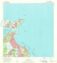
Kaneohe Marine Corps Air Station dominates the Mokapu Peninsula, revealing a complex mid-century military landscape complete with its own housing, schools like Mokapu Sch, and a golf course. The geography of the windward coast is defined by the massive volcanic landmark of Ulupau Crater and the extensive Kawainui Swamp, which separates the rising residential developments of Kailua from the inland slopes. This era shows significant suburban growth in neighborhoods such as Keolu Hills and Pohakupu, alongside established institutions like St Anthony Sch and Kailua High Sch.
Find a feature on this map
76 named features on this map. Tap any name to fly to it.
Don’t see what you’re looking for? This feature index may not catch every label — zoom into the map to look around manually.
Map Details
Editions of this 1968 Mokapu Map
2 editions found
Historical Maps of Kailua Through Time
69 maps found

1952 Koko Head
Honolulu County, HI

1952 Mokapu
Honolulu County, HI

1952 Waimea
Honolulu County, HI

1953 Ewa
Honolulu County, HI

1953 Puuloa
Honolulu County, HI

1954 Kaena
Honolulu County, HI

1954 Kahana
Honolulu County, HI

1954 Oahu
Honolulu County, HI

1959 Koko Head
Honolulu County, HI

1959 Mokapu
Honolulu County, HI

1959 Puuloa
Honolulu County, HI

1961 Oahu
Honolulu County, HI

1962 Ewa
Honolulu County, HI

1964 Kaena
Honolulu County, HI

1965 Oahu
Honolulu County, HI

1966 Waimea
Honolulu County, HI

1967 Kahana
Honolulu County, HI

1968 Ewa
Honolulu County, HI
1968 Mokapu
Honolulu County, HI

1968 Puuloa
Honolulu County, HI

1969 Koko Head
Honolulu County, HI

1970 Oahu
Honolulu County, HI

1977 Ewa
Honolulu County, HI

1977 Kaena
Honolulu County, HI

1977 Waimea
Honolulu County, HI

1978 Kahana
Honolulu County, HI

1978 Koko Head
Honolulu County, HI

1978 Mokapu
Honolulu County, HI

1981 Puuloa
Honolulu County, HI

1983 Ewa
Honolulu County, HI

1983 Kahana
Honolulu County, HI

1983 Koko Head
Honolulu County, HI

1983 Mokapu
Honolulu County, HI

1983 Pearl Harbor
Honolulu County, HI

1983 Waimea
Honolulu County, HI

1992 Kahana
Honolulu County, HI

1998 Ewa
Honolulu County, HI

1998 Kaena
Honolulu County, HI

1998 Mokapu Point
Honolulu County, HI

1998 Waimea
Honolulu County, HI

1999 Koko Head
Honolulu County, HI

1999 Pearl Harbor
Honolulu County, HI

2013 Ewa
Honolulu County, HI

2013 Kaena
Honolulu County, HI

2013 Kaena OE W
Honolulu County, HI

2013 Kahana
Honolulu County, HI

2013 Koko Head
Honolulu County, HI

2013 Koko Head OE E
Honolulu County, HI

2013 Mokapu Point
Honolulu County, HI

2013 Pearl Harbor
Honolulu County, HI

2013 Waimea
Honolulu County, HI

2017 Ewa
Honolulu County, HI

2017 Kaena
Honolulu County, HI

2017 Kaena OE W
Honolulu County, HI

2017 Kahana
Honolulu County, HI

2017 Koko Head
Honolulu County, HI

2017 Koko Head OE E
Honolulu County, HI

2017 Mokapu Point
Honolulu County, HI

2017 Pearl Harbor
Honolulu County, HI

2017 Waimea
Honolulu County, HI

2024 Ewa
Honolulu County, HI

2024 Kaena
Honolulu County, HI

2024 Kaena OE W
Honolulu County, HI

2024 Kahana
Honolulu County, HI

2024 Koko Head
Honolulu County, HI

2024 Koko Head OE E
Honolulu County, HI

2024 Mokapu Point
Honolulu County, HI

2024 Pearl Harbor
Honolulu County, HI

2024 Waimea
Honolulu County, HI