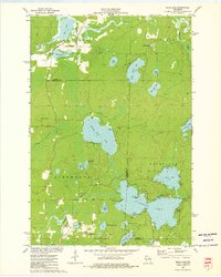
1973 Map of Mole Lake
USGS Topo · Published 1976About this map
The Indian Reservation Boundary cuts through this 1970s landscape, centered on the community of Mole Lake. The terrain is characterized by a dense network of glacial water bodies, with Rolling Stone Lake and Pickerel Lake serving as major hydrological landmarks. The area maintains a rural character with a scattering of religious and civic sites, such as the Kingdom Hall and the Lookout Tower located west of Spider Creek.
Find a feature on this map
42 named features on this map. Tap any name to fly to it.
Don’t see what you’re looking for? This feature index may not catch every label — zoom into the map to look around manually.
Map Details
Editions of this 1973 Mole Lake Map
This is the sole edition of this map. No revisions or reprints were ever made.
Other maps of this area

1939 · Crandon
USGS Topo · 1:48,000

1940 · Monico
USGS Topo · 1:48,000

1941 · Crandon
USGS Topo · 1:48,000

1942 · Elcho
USGS Topo · 1:48,000

1942 · Pearson
USGS Topo · 1:48,000

1947 · Crandon
USGS Topo · 1:48,000

1950 · Monico
USGS Topo · 1:48,000

1950 · Elcho
USGS Topo · 1:48,000

1950 · Lily
USGS Topo · 1:48,000

1954 · Iron Mountain
USGS Topo · 1:250,000