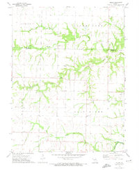
1972 Map of Molino
USGS Topo · Published 1974About this map
The South Fork Salt River drainage basin defines the landscape of this rural Audrain and Monroe County borderland. Several local congregations and their associated burial grounds serve as the primary community anchors, including New Hope Ch and its neighboring New Hope Cem, alongside Midway Ch and Olivet Ch. The map provides a detailed view of the Missouri countryside in the early 1970s, where small settlements like Molino and Skinner are connected by a network of local roads. Industrial activity is concentrated near Youngs Creek at the Quarries, while agricultural life is reflected in the placement of the Hi-Way R-3 Sch. Water management and monitoring are evident at the Gaging Station located along the river's upper reaches, providing a look at the hydrological infrastructure of the era.
Find a feature on this map
19 named features on this map. Tap any name to fly to it.
Don’t see what you’re looking for? This feature index may not catch every label — zoom into the map to look around manually.
Map Details
Editions of this 1972 Molino Map
This is the sole edition of this map. No revisions or reprints were ever made.
Other maps of this area

1890 · Mexico
USGS Topo · 1:125,000

1890 · Moberly
USGS Topo · 1:125,000

1932 · Mexico
USGS Topo · 1:62,500

1945 · Florida
USGS Topo · 1:62,500

1945 · Centralia
USGS Topo · 1:62,500

1948 · Quincy
USGS Topo · 1:250,000

1953 · Moberly
USGS Topo · 1:250,000

1954 · Moberly
USGS Topo · 1:250,000

1956 · Quincy
USGS Topo · 1:250,000

1957 · Moberly
USGS Topo · 1:250,000