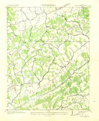
1935 Map of Moll Creek
USGS Topo · Published 1935About this map
Copper Ridge and Moccasin Ridge dominate the landscape in this 1935 survey, which details a rural stretch of Southwest Virginia along the boundary of Russell and Scott counties. The map captures a moment when travel through these limestone ridges relied on specific mountain gaps and named routes like the State Highway of the Lonesome Pine No 64. Small rural hubs such as Lawsons Store, Masons Store, and the curiously named Point Truth served as the primary gathering points for the surrounding hollows.
Find a feature on this map
56 named features on this map. Tap any name to fly to it.
Don’t see what you’re looking for? This feature index may not catch every label — zoom into the map to look around manually.
Map Details
Editions of this 1935 Moll Creek Map
This is the sole edition of this map. No revisions or reprints were ever made.
Other maps of this area

1897 · Bristol
USGS Topo · 1:125,000

1902 · Bristol
USGS Topo · 1:125,000

1918 · Carterton
USGS Topo · 1:62,500

1920 · Coeburn
USGS Topo · 1:48,000

1934 · Wallace
USGS Topo · 1:24,000

1934 · Hansonville
USGS Topo · 1:24,000
1934 · Carbo
USGS Topo · 1:24,000

1935 · Hilton
USGS Topo · 1:24,000

1935 · Mendota
USGS Topo · 1:24,000
1935 · Beaver Creek
USGS Topo · 1:48,000