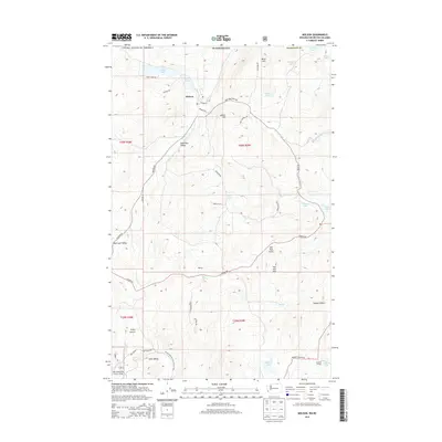
2014 Map of Molson
USGS Topo · Published 2014About this map
The settlement of Molson sits at the center of this high-plateau landscape along the international boundary, where agricultural patterns meet the foothills of the Okanogan Nat For. This borderlands region is defined by a series of small, scattered lakes including Sidley Lake, Molson Lake, and Teal Lake, which provide vital water sources in a landscape drained by Dry Cr and Mary Ann Cr. The terrain is punctuated by significant rises such as Block Hill and Molson Hill, while the southern reaches of the map transition into the forested slopes of Hee Hee Mtn.
Find a feature on this map
53 named features on this map. Tap any name to fly to it.
Don’t see what you’re looking for? This feature index may not catch every label — zoom into the map to look around manually.
Map Details
Editions of this 2014 Molson Map
This is the sole edition of this map. No revisions or reprints were ever made.
Other maps of this area

1902 · Osoyoos
USGS Topo · 1:125,000

1904 · Osoyoos
USGS Topo · 1:125,000

1954 · Okanogan
USGS Topo · 1:250,000

1957 · Mt. Bonaparte
USGS Topo · 1:62,500

1957 · Oroville
USGS Topo · 1:62,500

1958 · Okanogan
USGS Topo · 1:250,000
1981 · Burge Mtn
USGS Topo · 1:24,000

1981 · Mount Hull
USGS Topo · 1:24,000

1984 · Oroville
USGS Topo · 1:100,000
1988 · Mt Bonaparte
USGS Topo · 1:24,000