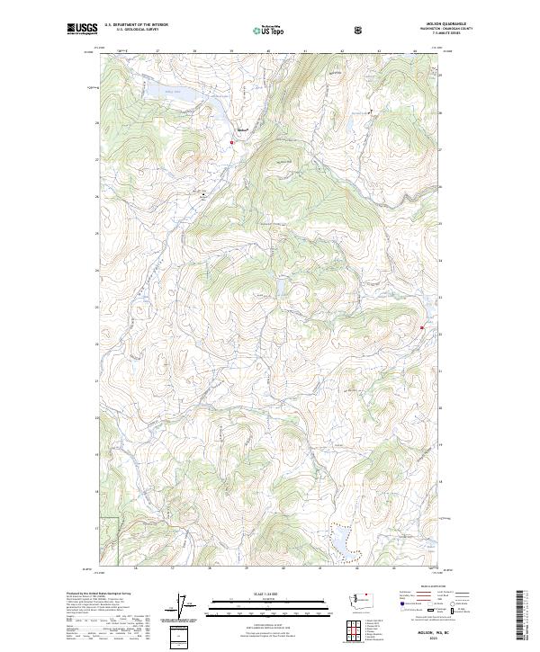
2023 Map of Molson
USGS Topo · Published 2023About this map
Molson anchors the high plateau of the Okanogan Highlands in this contemporary survey, where the settlement’s history is etched into the landscape near the Canadian border. The townsite is situated between Sidley Lake and Molson Lake, with the Molson Cem located to the southwest along Co HWY 4804. The terrain is defined by a series of north-south running valleys and ridges, including Mud Lake Valley and Eden Valley, punctuated by landmarks like Molson Hill and the uniquely named Hee Hee Mtn. To the south, the map transition into the northern reaches of the Okanogan National Forest near Haley Canyon. A network of rural routes, including the evocatively named Heaven Bound Rd and Old Railroad Rd, traces the paths of earlier pioneers and industry through this ranching and upland environment.
Find a feature on this map
71 named features on this map. Tap any name to fly to it.
Don’t see what you’re looking for? This feature index may not catch every label — zoom into the map to look around manually.
Map Details
Editions of this 2023 Molson Map
This is the sole edition of this map. No revisions or reprints were ever made.
Other maps of this area

1902 · Osoyoos
USGS Topo · 1:125,000

1904 · Osoyoos
USGS Topo · 1:125,000

1954 · Okanogan
USGS Topo · 1:250,000

1957 · Mt. Bonaparte
USGS Topo · 1:62,500

1957 · Oroville
USGS Topo · 1:62,500

1958 · Okanogan
USGS Topo · 1:250,000
1981 · Burge Mtn
USGS Topo · 1:24,000

1981 · Mount Hull
USGS Topo · 1:24,000

1984 · Oroville
USGS Topo · 1:100,000
1988 · Mt Bonaparte
USGS Topo · 1:24,000