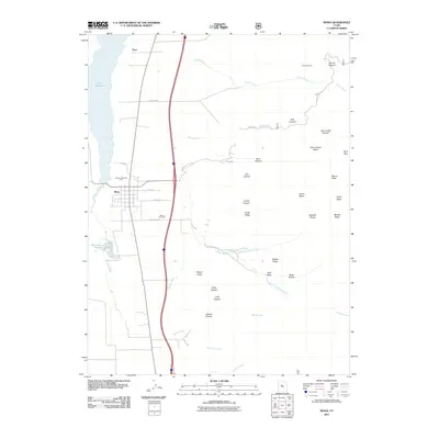
2011 Map of Mona
USGS Topo · Published 2011About this map
Mona sits at the foot of the Wasatch Range in this early 21st-century study, where the valley floor transitions into the steep elevations of Mount Nebo. The settlement's grid is bounded by Pioneer Memorial Park and extends south toward the Mona Cemetery along Cemetery Ln. To the west, the landscape is defined by the significant waters of Mona Reservoir and the Burriston Ponds, fed by drainage from Currant Creek. The eastern half of the map is dominated by the complex vertical terrain of the mountains, featuring numerous named drainages such as John Jones Canyon and Pole Canyon. This era shows a high level of detail in the canyon systems and mountain passes, including Wolf Pass. Evidence of earlier industrial activity persists high in the terrain at the Privateer Mine, located near Broad Canyon. This map captures the intersection of organized rural settlement, water management, and the formidable natural barriers of the Utah interior.
Find a feature on this map
46 named features on this map. Tap any name to fly to it.
Don’t see what you’re looking for? This feature index may not catch every label — zoom into the map to look around manually.
Map Details
Editions of this 2011 Mona Map
This is the sole edition of this map. No revisions or reprints were ever made.
Other maps of this area

1885 · Manti
USGS Topo · 1:250,000

1895 · Manti
USGS Topo · 1:250,000

1951 · Moroni
USGS Topo · 1:62,500

1951 · Santaquin
USGS Topo · 1:62,500

1951 · Nephi
USGS Topo · 1:62,500

1952 · Santaquin Peak
USGS Topo · 1:62,500

1956 · Price
USGS Topo · 1:250,000

1960 · Price
USGS Topo · 1:250,000

1962 · Price
USGS Topo · 1:250,000
1979 · Goshen
USGS Topo · 1:24,000