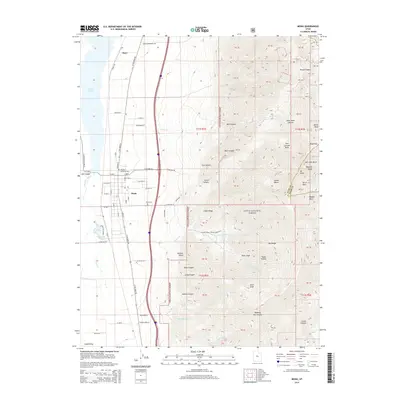
2014 Map of Mona
USGS Topo · Published 2014About this map
Mona sits at the eastern edge of the Juab Valley, where the valley floor meets the dramatic rise of the Wasatch Range. This 2014 landscape is defined by the steep transition from the irrigated fields and settlements along the valley floor to the high-altitude wilderness of the Uinta National Forest. The map captures a detailed view of the water systems essential to this region, from the Mona Reservoir and the spring-fed Burraston Ponds to the numerous canyons like Dry Canyon and Bear Canyon that drain the mountain front. Genealogists and local historians can locate specific landmarks such as the Mona Cem and Pioneer Memorial Park, while the presence of Nortonville and Starr illustrates the historical settlement pattern along the old mountain road at the base of Mt Nebo.
Find a feature on this map
93 named features on this map. Tap any name to fly to it.
Don’t see what you’re looking for? This feature index may not catch every label — zoom into the map to look around manually.
Map Details
Editions of this 2014 Mona Map
This is the sole edition of this map. No revisions or reprints were ever made.
Other maps of this area

1885 · Manti
USGS Topo · 1:250,000

1895 · Manti
USGS Topo · 1:250,000

1951 · Moroni
USGS Topo · 1:62,500

1951 · Santaquin
USGS Topo · 1:62,500

1951 · Nephi
USGS Topo · 1:62,500

1952 · Santaquin Peak
USGS Topo · 1:62,500

1956 · Price
USGS Topo · 1:250,000

1960 · Price
USGS Topo · 1:250,000

1962 · Price
USGS Topo · 1:250,000
1979 · Goshen
USGS Topo · 1:24,000