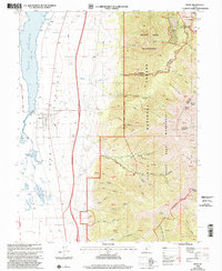
1998 Map of Mona
USGS Topo · Published 2002About this map
Juab Valley serves as a stark transition between the irrigated lowlands and the towering peaks of the Uinta National Forest in the late 1990s. The town of Mona is established at the base of the massif, where Mona Creek and several springs flow toward the expansive Mona Reservoir. Local genealogy and land use are well-documented through sites like the Mona Cem and the Pioneer Memorial Park (Cem), alongside remnants of the region's extraction history such as the Privateer Mine and various Gravel Pits.
Find a feature on this map
55 named features on this map. Tap any name to fly to it.
Don’t see what you’re looking for? This feature index may not catch every label — zoom into the map to look around manually.
Map Details
Editions of this 1998 Mona Map
This is the sole edition of this map. No revisions or reprints were ever made.
Other maps of this area

1885 · Manti
USGS Topo · 1:250,000

1895 · Manti
USGS Topo · 1:250,000

1951 · Moroni
USGS Topo · 1:62,500

1951 · Santaquin
USGS Topo · 1:62,500

1951 · Nephi
USGS Topo · 1:62,500

1952 · Santaquin Peak
USGS Topo · 1:62,500

1956 · Price
USGS Topo · 1:250,000

1960 · Price
USGS Topo · 1:250,000

1962 · Price
USGS Topo · 1:250,000
1979 · Goshen
USGS Topo · 1:24,000