1995 Map of Monarch
USGS Topo · Published 1997About this map
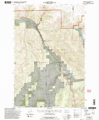
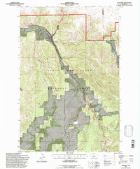
Monarch sits at the confluence of the Dry Fork Belt Creek and Belt Creek, a settlement shaped by the winding geography of Monarch Canyon. The landscape is dominated by the steep slopes of Monarch Mountain and the high elevation of Keegan Peak, situated within the protected boundaries of the Lewis and Clark National Forest. An Old Railroad Grade traces the path of the creek through the canyon, providing a clear record of the transportation infrastructure that once connected this mountain community to larger markets.
Find a feature on this map
42 named features on this map. Tap any name to fly to it.
Don’t see what you’re looking for? This feature index may not catch every label — zoom into the map to look around manually.
Map Details
Editions of this 1995 Monarch Map
2 editions found
Other maps of this area

1886 · Little Belt Mts.
USGS Topo · 1:250,000

1890 · Fort Benton
USGS Topo · 1:250,000

1892 · Fort Benton
USGS Topo · 1:250,000

1894 · Little Belt Mts.
USGS Topo · 1:250,000

1897 · Fort Benton
USGS Topo · 1:250,000

1897 · Little Belt Mts.
USGS Topo · 1:250,000

1898 · Little Belt Mts.
USGS Topo · 1:250,000

1902 · Little Belt Mts.
USGS Topo · 1:250,000

1948 · White Sulphur Springs
USGS Topo · 1:250,000

1954 · Great Falls
USGS Topo · 1:250,000