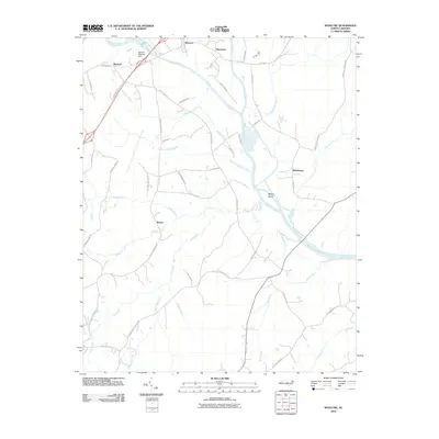
2010 Map of Moncure
USGS Topo · Published 2010About this map
Deep River and Haw River converge at the heart of this landscape to form the Cape Fear River, a major hydrological junction that has historically defined the region's geography and transport. The confluence is marked by McKay Island, while further upstream, the Ramsey Millpond Dam regulates the flow near the settlement of Blacknel. Small rural communities such as Moncure, Haywood, Rosser, and Brickhaven are connected by a network of winding roads, including Old US 1 and Lick Creek Rd. Numerous drainage systems like Wombles Creek and Lick Creek carve through the terrain, illustrating the intricate watershed that feeds the Cape Fear. The presence of the C P and L Rd railroad suggests the ongoing importance of industrial and utility infrastructure within this river-centered corridor.
Find a feature on this map
46 named features on this map. Tap any name to fly to it.
Don’t see what you’re looking for? This feature index may not catch every label — zoom into the map to look around manually.
Map Details
Editions of this 2010 Moncure Map
This is the sole edition of this map. No revisions or reprints were ever made.
Other maps of this area

1953 · Raleigh
USGS Topo · 1:250,000

1954 · Raleigh
USGS Topo · 1:250,000

1969 · New Hope Dam
USGS Topo · 1:24,000

1970 · Pittsboro
USGS Topo · 1:24,000

1970 · Colon
USGS Topo · 1:24,000

1970 · Moncure
USGS Topo · 1:24,000
1974 · New Hill
USGS Topo · 1:24,000

1974 · Mamers
USGS Topo · 1:24,000
1974 · Cokesbury
USGS Topo · 1:24,000

1974 · Sanford
USGS Topo · 1:24,000