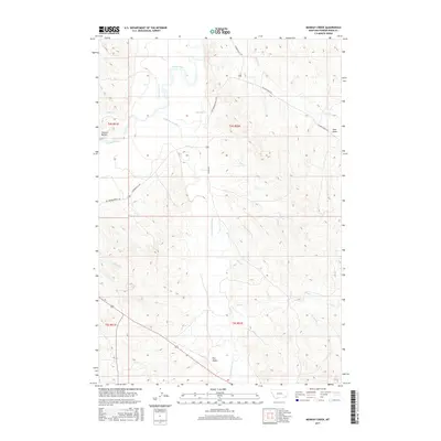
2017 Map of Monday Creek
USGS Topo · Published 2017About this map
The confluence of the Little Powder River and the Powder River anchors this landscape in southeastern Montana. The map illustrates a drainage network defined by seasonal watercourses like Monday Cr, Government Cr, and Bobcat Cr carving through the prairie. To the west, the distinctive Preston Buttes provide a prominent topographical landmark, while to the east, the terrain rises toward Hart Draw. Long-established ranching routes such as the Big Powder River E Rd and Pilgrim Creek Rd follow the natural contours of the land, connecting remote grazing territories. The map reveals the intricate dissection of the plains by numerous small tributaries including Annis Cr and Little Corrals Cr, reflecting a topography shaped by persistent erosion and the sparse, vital water sources of the region.
Find a feature on this map
26 named features on this map. Tap any name to fly to it.
Don’t see what you’re looking for? This feature index may not catch every label — zoom into the map to look around manually.
Map Details
Editions of this 2017 Monday Creek Map
This is the sole edition of this map. No revisions or reprints were ever made.
Other maps of this area

1954 · Ekalaka
USGS Topo · 1:250,000

1956 · Ekalaka
USGS Topo · 1:250,000

1958 · Ekalaka
USGS Topo · 1:250,000

1965 · Ekalaka
USGS Topo · 1:250,000

1973 · Monday Creek
USGS Topo · 1:24,000

1973 · Moonlight Creek
USGS Topo · 1:24,000

1973 · Hawkey Creek
USGS Topo · 1:24,000
1973 · Fighting Butte
USGS Topo · 1:24,000
1973 · Eldon Mountain
USGS Topo · 1:24,000
1973 · Broadus
USGS Topo · 1:24,000