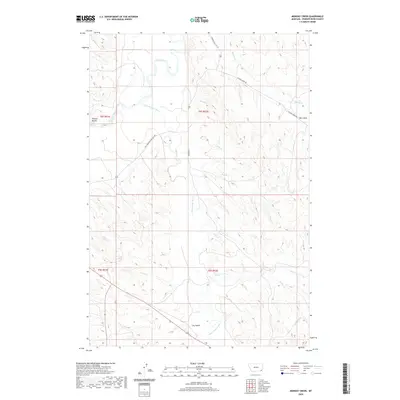
2020 Map of Monday Creek
USGS Topo · Published 2020About this map
The Little Powder River and Powder River converge in this southeastern Montana landscape, defining a network of drainage basins and high plains topography. The terrain is marked by distinctive elevations such as Preston Buttes and etched by a series of seasonal and permanent waterways including Monday Cr, Pilgrim Cr, and Hell Cr. This 2020 survey illustrates the modern road network that provides access to this isolated region, featuring routes like Powderville East Rd, Big Powder River-East Rd, and Pilgrim Creek Rd. The map is characterized by its numerous small creek systems, from Annis Cr and Plum Cr to the more southern Butte Cr, which carve through the land and dictate the local geography. Significant landmarks like Hart Draw and Dry Gulch indicate the arid character of the area, while the placement of Corral Cr and Little Corral Cr suggests the enduring influence of cattle ranching on the naming of these remote features.
Find a feature on this map
26 named features on this map. Tap any name to fly to it.
Don’t see what you’re looking for? This feature index may not catch every label — zoom into the map to look around manually.
Map Details
Editions of this 2020 Monday Creek Map
This is the sole edition of this map. No revisions or reprints were ever made.
Other maps of this area

1954 · Ekalaka
USGS Topo · 1:250,000

1956 · Ekalaka
USGS Topo · 1:250,000

1958 · Ekalaka
USGS Topo · 1:250,000

1965 · Ekalaka
USGS Topo · 1:250,000

1973 · Monday Creek
USGS Topo · 1:24,000

1973 · Moonlight Creek
USGS Topo · 1:24,000

1973 · Hawkey Creek
USGS Topo · 1:24,000
1973 · Fighting Butte
USGS Topo · 1:24,000
1973 · Eldon Mountain
USGS Topo · 1:24,000
1973 · Broadus
USGS Topo · 1:24,000