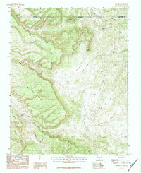
1983 Map of Monero
USGS Topo · Published 1983About this map
The Tierra Amarilla Grant defines much of this high-elevation landscape along the border between Colorado and New Mexico. The terrain is characterized by massive elevated flats such as Mesa Diamante, Briggs Mesa, and Abeyta Mesa, which are carved by deep drainages including Reed Canyon and Miller Canyon. A significant escarpment separates the higher mesa tops from the lower Valle Diamante. Water management in this arid environment is evident through features like the Crowley Reservoir, Tecolote Lake, and Stove Tank. The map reveals the complex topography surrounding Monero Mountain, where numerous gulches and creeks, such as Amargo Creek and Webb Creek, draw from the surrounding heights. This 1980s survey captures a transition point in the geography where the rugged Rincon de la Aguila meets the expansive grant lands.
Find a feature on this map
31 named features on this map. Tap any name to fly to it.
Don’t see what you’re looking for? This feature index may not catch every label — zoom into the map to look around manually.
Map Details
Editions of this 1983 Monero Map
This is the sole edition of this map. No revisions or reprints were ever made.
Other maps of this area

1913 · Summitville
USGS Topo · 1:125,000

1915 · Summitville
USGS Topo · 1:125,000

1945 · Durango
USGS Topo · 1:250,000

1953 · Durango
USGS Topo · 1:250,000

1954 · Durango
USGS Topo · 1:250,000

1954 · Aztec
USGS Topo · 1:250,000

1955 · Chama
USGS Topo · 1:62,500

1955 · Lumberton
USGS Topo · 1:62,500

1957 · Chromo
USGS Topo · 1:62,500

1957 · Chama Peak
USGS Topo · 1:62,500