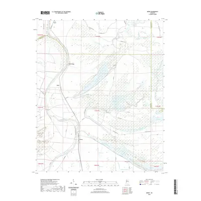
2020 Map of Money
USGS Topo · Published 2020About this map
The Tallahatchie River meanders through the heart of this Delta landscape, defining the rural character of northern Leflore County. Centered on the community of Money, the map reveals a complex network of bayous and oxbow lakes, including Money Bayou, Tippo Bayou, and the Yalobusha River which edges the eastern boundary. The presence of Pleasantview Plantation Rd and several family or plantation-related burial grounds, such as Eagle Plantation Cem and Eastmoney Cem, provides significant geographic context for local genealogists. Small settlements like Ruby and Sandy Ridge are situated along the river's path, connected by a web of rural routes like Six Mile Rd and Sunnyside Rd. This 2020 update offers a clear view of the contemporary drainage patterns and land divisions that have shaped this agricultural region for generations.
Find a feature on this map
76 named features on this map. Tap any name to fly to it.
Don’t see what you’re looking for? This feature index may not catch every label — zoom into the map to look around manually.
Map Details
Editions of this 2020 Money Map
This is the sole edition of this map. No revisions or reprints were ever made.
Other maps of this area

1931 · Schlater
USGS Topo · 1:48,000

1931 · Sumner
USGS Topo · 1:48,000

1932 · Philipp
USGS Topo · 1:48,000

1934 · Schlater
USGS Topo · 1:62,500

1935 · Sumner
USGS Topo · 1:62,500

1935 · Philipp
USGS Topo · 1:62,500

1936 · Greenwood
USGS Topo · 1:62,500

1939 · Schlater
USGS Topo · 1:62,500

1939 · Sumner
USGS Topo · 1:62,500

1939 · Philipp
USGS Topo · 1:62,500