
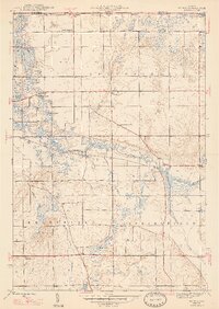
1947 Map of Mongo
USGS Topo · Published 1947About this map
Pigeon River meanders across this northern Indiana landscape, anchoring a water-rich region of LaGrange County just south of the Michigan border in the years following World War II. The settlement of Mongo sits at a strategic bend in the river, adjacent to the Mongo Reservoir, while the smaller communities of Brighton and Plato are situated along the regional road network. This era reflects a rural society supported by local institutions, evidenced by Pretty Prairie Ch, English Prairie Ch, and the Hoff Sch. The intricate topography of the area is defined by numerous glacial lakes, including Cedar Lake, Duff Lake, and Donaldson Lake, alongside water management features such as the Nasby Dam. The transition between the townships of Greenfield, Bloomfield, and Springfield is clearly delineated, showing a landscape where agricultural clearings and wetlands alternate across the terrain.
Find a feature on this map
29 named features on this map. Tap any name to fly to it.
Don’t see what you’re looking for? This feature index may not catch every label — zoom into the map to look around manually.
Map Details
Editions of this 1947 Mongo Map
2 editions found
Other maps of this area

1940 · Orland
USGS Topo · 1:24,000

1941 · Orland
USGS Topo · 1:24,000

1942 · Stroh
USGS Topo · 1:24,000

1947 · Lagrange
USGS Topo · 1:24,000

1947 · Wolcottville
USGS Topo · 1:24,000

1947 · Oliver Lake
USGS Topo · 1:24,000

1953 · Fort Wayne
USGS Topo · 1:250,000

1956 · Fort Wayne
USGS Topo · 1:250,000

1959 · Wolcottville
USGS Topo · 1:24,000
1959 · Stroh
USGS Topo · 1:24,000