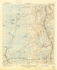
1942 Map of Moniac
USGS Topo · Published 1944About this map
Trail Ridge forms a prominent North-South spine through this Georgia-Florida borderland, dividing the dense wetlands of the Okefenokee Swamp to the west from the drainage of the St Marys River to the east. This 1917 survey, updated for the 1942 edition, illustrates a landscape where settlement is closely tied to the high ground of the ridge and the Southern and Florida railroad corridor. Communities such as Moniac, St George, and Toledo serve as local hubs, supported by a network of rural institutions like the Stave Branch School and Deep Creek Church. The map details the complex interior of the swamp, naming numerous islands and prairies including Chesser Island and Grand Prairie. Of particular historical interest is Ellicotts Mound, a significant boundary marker on the Georgia Florida state line, and industrial remnants like Olivers Mill.
Find a feature on this map
57 named features on this map. Tap any name to fly to it.
Don’t see what you’re looking for? This feature index may not catch every label — zoom into the map to look around manually.
Map Details
Editions of this 1942 Moniac Map
2 editions found

Other maps of this area

1917 · Cambon
USGS Topo · 1:62,500

1917 · Boulogne
USGS Topo · 1:62,500

1917 · Macclenny
USGS Topo · 1:62,500

1917 · Hilliard
USGS Topo · 1:62,500

1918 · Folkston
USGS Topo · 1:62,500

1918 · Moniac
USGS Topo · 1:62,500

1918 · Cambon
USGS Topo · 1:62,500

1918 · Macclenny
USGS Topo · 1:62,500

1919 · Hilliard
USGS Topo · 1:62,500

1919 · Boulogne
USGS Topo · 1:62,500