
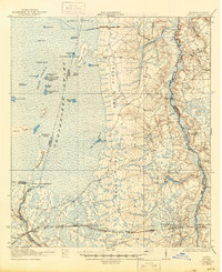
1942 Map of Moniac
USGS Topo · Published 1942About this map
The vast eastern reaches of the Okefenokee Swamp dominate the landscape of Charlton County, where the wilderness transitions into the prominent elevation of Trail Ridge. This 1917 survey, reissued during the war years, documents the sparse settlement patterns along the Georgia-Florida border. The rugged interior is dotted with remote islands such as Chesser Island and Soldiers Camp Island, while a series of named prairies like Mizell Prairie and Grand Prairie break the wetland expanse.
Find a feature on this map
61 named features on this map. Tap any name to fly to it.
Don’t see what you’re looking for? This feature index may not catch every label — zoom into the map to look around manually.
Map Details
Editions of this 1942 Moniac Map
2 editions found
Other maps of this area

1917 · Cambon
USGS Topo · 1:62,500

1917 · Boulogne
USGS Topo · 1:62,500

1917 · Macclenny
USGS Topo · 1:62,500

1917 · Hilliard
USGS Topo · 1:62,500

1918 · Folkston
USGS Topo · 1:62,500

1918 · Moniac
USGS Topo · 1:62,500

1918 · Cambon
USGS Topo · 1:62,500

1918 · Macclenny
USGS Topo · 1:62,500

1919 · Hilliard
USGS Topo · 1:62,500

1919 · Boulogne
USGS Topo · 1:62,500