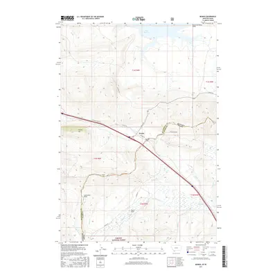
2017 Map of Monida
USGS Topo · Published 2017About this map
Monida sits at a critical high-altitude junction where the Continental Divide meets the boundary between Montana and Idaho. This 2017 survey details the rugged crossing at Monida Pass, a historically significant gap that facilitates travel between the Centennial Valley to the north and the expansive timberlands of the Targhee National Forest to the south. The landscape is defined by its water systems, from the marshy northern reaches of the Lima Reservoir to the branching headwaters of Beaver Cr and Modoc Cr. Evidence of the area's ranching and transit heritage remains visible through the network of local routes like Grover Ranch Rd and the path of Old Hwy 91, which parallel the modern interstate corridor. High points such as Pinetop Hill and the Knoll provide geographic context for this high-mountain transit hub.
Find a feature on this map
29 named features on this map. Tap any name to fly to it.
Don’t see what you’re looking for? This feature index may not catch every label — zoom into the map to look around manually.
Map Details
Editions of this 2017 Monida Map
This is the sole edition of this map. No revisions or reprints were ever made.
Other maps of this area

1955 · Dubois
USGS Topo · 1:250,000

1957 · Paul Reservoir
USGS Topo · 1:62,500

1958 · Dubois
USGS Topo · 1:250,000

1968 · Corral Creek
USGS Topo · 1:24,000

1968 · Lima Dam
USGS Topo · 1:24,000

1968 · Snowline
USGS Topo · 1:24,000

1968 · Monida
USGS Topo · 1:24,000

1968 · Henry Gulch
USGS Topo · 1:24,000
1968 · Wolverine Creek
USGS Topo · 1:24,000

1972 · Spencer North
USGS Topo · 1:24,000