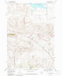
1968 Map of Monida
USGS Topo · Published 1987About this map
The high-altitude borderlands between Montana and Idaho are defined here by the Continental Divide and the critical transportation corridor of Monida Pass. The small settlement of Monida serves as a focal point along the Union Pacific rail line, which snakes through the mountain terrain alongside the interstate highway. To the north, the wide Centennial Valley opens up, dominated by the waters of the Lima Reservoir. This survey captures a landscape of intense hydrography and topography, where Beaver Creek and its many tributaries, including Modoc Creek and Berry Creek, drain the southern slopes within the Targhee National Forest. Local landmarks like the Airway Beacon and Pinetop Hill mark the high ground near the state boundary, illustrating the area's role in both aviation navigation and early transcontinental travel routes through the Northern Rockies.
Find a feature on this map
20 named features on this map. Tap any name to fly to it.
Don’t see what you’re looking for? This feature index may not catch every label — zoom into the map to look around manually.
Map Details
Editions of this 1968 Monida Map
2 editions found
Other maps of this area

1955 · Dubois
USGS Topo · 1:250,000

1957 · Paul Reservoir
USGS Topo · 1:62,500

1958 · Dubois
USGS Topo · 1:250,000

1968 · Corral Creek
USGS Topo · 1:24,000

1968 · Lima Dam
USGS Topo · 1:24,000

1968 · Snowline
USGS Topo · 1:24,000

1968 · Monida
USGS Topo · 1:24,000

1968 · Henry Gulch
USGS Topo · 1:24,000
1968 · Wolverine Creek
USGS Topo · 1:24,000

1972 · Spencer North
USGS Topo · 1:24,000