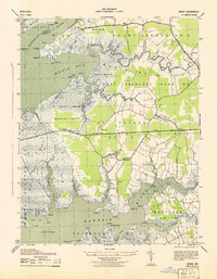
1943 Map of Monie
USGS Topo · Published 1943About this map
The salt marshes and tidal guts of Somerset County define this coastal landscape as it appeared during the early 1940s. Centered on the intersection of Monie Bay and the Manokin River, the terrain is a complex network of wetlands including Monie Marsh and St Peters Marsh. Small settlements like Oriole, Venton, and Mount Vernon are linked by a developing road network, including State Route 363. The presence of St Peters ME Church and St James ME Church near Oriole points to the established community centers of the era. Maritime navigation is marked by the Wicomico River Light 14 at the mouth of the Wicomico River, reflecting the region's reliance on these waterways for transport and trade. From the secluded docks at Inverness to the isolated School Chimney, the map captures a rural Maryland peninsula shaped by its proximity to the Chesapeake.
Find a feature on this map
83 named features on this map. Tap any name to fly to it.
Don’t see what you’re looking for? This feature index may not catch every label — zoom into the map to look around manually.
Map Details
Editions of this 1943 Monie Map
This is the sole edition of this map. No revisions or reprints were ever made.
Other maps of this area

1901 · Salisbury
USGS Topo · 1:62,500

1903 · Nanticoke
USGS Topo · 1:62,500

1903 · Deal Island
USGS Topo · 1:62,500

1942 · Terrapin Sand Point
USGS Topo · 1:24,000

1942 · Marion
USGS Topo · 1:24,000

1942 · Deal Island
USGS Topo · 1:24,000

1942 · Monie
USGS Topo · 1:24,000

1942 · Wetipquin
USGS Topo · 1:24,000

1942 · Kingston
USGS Topo · 1:24,000

1942 · Princess Anne
USGS Topo · 1:24,000