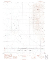
1987 Map of Monitor Peak
USGS Topo · Published 1988About this map
Nellis Air Force Range dominates the southern landscape of this high-desert quadrangle, where the boundary of a Restricted Access Area runs parallel to a surveyed Base Line. This late 1980s topographical study captures the vast expanse of the Ralston Valley, a basin defined by intermittent drainage and specialized infrastructure like a cross-country Trans Line. To the east, the terrain rises sharply into the Monitor Hills, culminating at the 6,373-foot summit of Monitor Peak. The isolation of the region is evident in the sparse human markers, limited primarily to a single Well and a Borrow Pit, reflecting an era of military land use and geologic survey in the Nevada desert.
Find a feature on this map
9 named features on this map. Tap any name to fly to it.
Don’t see what you’re looking for? This feature index may not catch every label — zoom into the map to look around manually.
Map Details
Editions of this 1987 Monitor Peak Map
This is the sole edition of this map. No revisions or reprints were ever made.
Other maps of this area

1907 · Tonopah
USGS Topo · 1:250,000

1908 · Kawich
USGS Topo · 1:250,000

1908 · Lida
USGS Topo · 1:250,000

1908 · Tonopah
USGS Topo · 1:250,000

1913 · Lida
USGS Topo · 1:250,000

1942 · Cactus Range
USGS Topo · 1:125,000

1945 · Goldfield
USGS Topo · 1:125,000

1952 · Mud Lake
USGS Topo · 1:62,500

1952 · Cactus Peak
USGS Topo · 1:62,500

1954 · Goldfield
USGS Topo · 1:250,000