
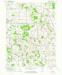
1962 Map of Monon NE
USGS Topo · Published 1963About this map
Agricultural drainage and the intricate water management of the Kankakee outwash plain define this 1962 landscape near the border of Pulaski and White Counties. The map reveals a highly engineered network of waterways, including Hubbell Ditch, Beaver Ditch, and Weltzin Ditch, which dominate the townships of Jefferson, Beaver, and Salem. These man-made channels follow section lines, supporting the region's transition into intensive farming while Big Monon Creek and Monon Creek wind more naturally toward the southern edge of the sheet.
Find a feature on this map
26 named features on this map. Tap any name to fly to it.
Don’t see what you’re looking for? This feature index may not catch every label — zoom into the map to look around manually.
Map Details
Editions of this 1962 Monon NE Map
This is the sole edition of this map. No revisions or reprints were ever made.
Other maps of this area

1953 · Chicago
USGS Topo · 1:250,000

1953 · Danville
USGS Topo · 1:250,000

1955 · Danville
USGS Topo · 1:250,000

1956 · Danville
USGS Topo · 1:250,000

1957 · Chicago
USGS Topo · 1:250,000

1962 · Buffalo
USGS Topo · 1:24,000

1962 · Monon
USGS Topo · 1:24,000

1962 · Monticello North
USGS Topo · 1:24,000

1962 · Medaryville
USGS Topo · 1:24,000
1962 · Ripley
USGS Topo · 1:24,000