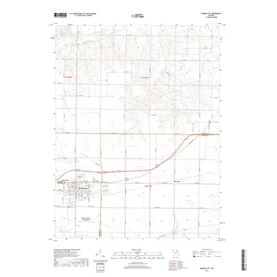
2017 Map of Monroe City
USGS Topo · Published 2017About this map
Monroe City sits at the junction of Marion, Monroe, and Ralls counties, serving as a regional hub defined by its grid of residential streets and industrial development. This 2017 survey shows the town's expansion along Industrial Dr and the southern corridor near the Captain Ben Smith Airfield - Monroe City Airport. Beyond the urban center, the landscape is a network of rural roads such as Laredo Ave and Marion Ln, connecting outlying settlements like Hassard and Ely. To the north, the terrain is carved by the South Fork North River and its numerous tributaries, including Sees Cr and Cedar Cr. Small water bodies like Gottman Lake and Monroe Lake B provide focal points within the agricultural surroundings. The inclusion of the Cobb Cem offers a grounded point for genealogical research in this tri-county borderland.
Find a feature on this map
94 named features on this map. Tap any name to fly to it.
Don’t see what you’re looking for? This feature index may not catch every label — zoom into the map to look around manually.
Map Details
Editions of this 2017 Monroe City Map
This is the sole edition of this map. No revisions or reprints were ever made.
Other maps of this area

1903 · Palmyra
USGS Topo · 1:125,000

1948 · Quincy
USGS Topo · 1:250,000

1949 · Palmyra
USGS Topo · 1:24,000

1949 · Philadelphia
USGS Topo · 1:24,000

1950 · Palmyra
USGS Topo · 1:24,000

1950 · Philadelphia
USGS Topo · 1:24,000

1956 · Quincy
USGS Topo · 1:250,000
1958 · Rensselaer
USGS Topo · 1:24,000

1959 · Monroe City
USGS Topo · 1:24,000

1959 · Joanna
USGS Topo · 1:24,000