
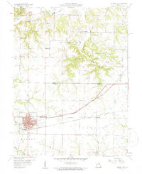
1959 Map of Monroe City
USGS Topo · Published 1960About this map
Monroe City serves as a significant rail hub in this late 1950s landscape, positioned at the intersection of three counties—Marion, Ralls, and Monroe. The town's grid is anchored by the High Sch and Washington Sch, with public green spaces at North Park and South Park. Transport and industry are central to the area's layout, as seen in the prominent routes of the Chicago Burlington and Quincy and the Wabash railroads which bisect the territory near the Sewage Disposal plant and city Mill.
Find a feature on this map
33 named features on this map. Tap any name to fly to it.
Don’t see what you’re looking for? This feature index may not catch every label — zoom into the map to look around manually.
Map Details
Editions of this 1959 Monroe City Map
2 editions found
Other maps of this area

1903 · Palmyra
USGS Topo · 1:125,000

1948 · Quincy
USGS Topo · 1:250,000

1949 · Palmyra
USGS Topo · 1:24,000

1949 · Philadelphia
USGS Topo · 1:24,000

1950 · Palmyra
USGS Topo · 1:24,000

1950 · Philadelphia
USGS Topo · 1:24,000

1956 · Quincy
USGS Topo · 1:250,000
1958 · Rensselaer
USGS Topo · 1:24,000

1959 · Joanna
USGS Topo · 1:24,000
1959 · Center
USGS Topo · 1:24,000