
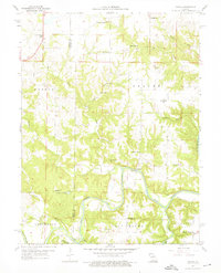
1959 Map of Joanna
USGS Topo · Published 1960About this map
Salt River meanders through the heart of this landscape along the border of Monroe and Ralls Counties, carving deep valleys through the surrounding terrain. In this pre-lake era, the small settlement of Joanna sits on the bluffs overlooking the river, serving as a focal point for a dispersed rural community defined by its one-room schoolhouses and country churches. The map captures an intricate network of local education and faith, featuring numerous landmarks such as Hereford Sch, Madden Sch, and Bethlehem Ch.
Find a feature on this map
35 named features on this map. Tap any name to fly to it.
Don’t see what you’re looking for? This feature index may not catch every label — zoom into the map to look around manually.
Map Details
Editions of this 1959 Joanna Map
2 editions found
Other maps of this area

1890 · Mexico
USGS Topo · 1:125,000

1903 · Palmyra
USGS Topo · 1:125,000

1945 · Florida
USGS Topo · 1:62,500

1945 · Perry
USGS Topo · 1:62,500

1948 · Quincy
USGS Topo · 1:250,000

1956 · Quincy
USGS Topo · 1:250,000
1958 · Rensselaer
USGS Topo · 1:24,000

1959 · Monroe City
USGS Topo · 1:24,000
1959 · Center
USGS Topo · 1:24,000

1959 · Hunnewell
USGS Topo · 1:24,000