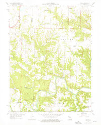
1959 Map of Joanna
USGS Topo · Published 1976About this map
The winding Salt River carves a deep path through this section of Ralls and Monroe counties, defining the rural character of the late 1950s. The landscape is dotted with small-scale community landmarks, including the namesake settlement of Joanna and the nearby Ely. A dense network of rural schools, such as Mudd Sch and Rocklick Sch, suggests a distributed population common before mid-century consolidation. The river's influence on local travel is evident at Shaver Ford and County Line Ford, where crossings relied on natural river levels. In the southern half of the quadrangle, Henderson Lake and a local Quarry indicate early shifts toward resource management and industrial use in an otherwise agrarian setting. Significant family and community history is preserved in sites like Utterback Cem and Mt Hope Ch, which served as anchors for the surrounding townships of Saline and Center.
Find a feature on this map
38 named features on this map. Tap any name to fly to it.
Don’t see what you’re looking for? This feature index may not catch every label — zoom into the map to look around manually.
Map Details
Editions of this 1959 Joanna Map
2 editions found
Other maps of this area

1890 · Mexico
USGS Topo · 1:125,000

1903 · Palmyra
USGS Topo · 1:125,000

1945 · Florida
USGS Topo · 1:62,500

1945 · Perry
USGS Topo · 1:62,500

1948 · Quincy
USGS Topo · 1:250,000

1956 · Quincy
USGS Topo · 1:250,000
1958 · Rensselaer
USGS Topo · 1:24,000

1959 · Monroe City
USGS Topo · 1:24,000

1959 · Joanna
USGS Topo · 1:24,000
1959 · Center
USGS Topo · 1:24,000