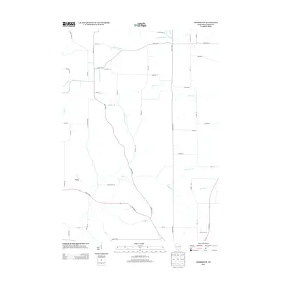
2013 Map of Monroe NW
USGS Topo · Published 2013About this map
The rolling agricultural landscape of Northwest Monroe in Green County is defined by a dense network of creek branches and rural roads named for the families who settled here. The northern reaches are drained by South Br Hefty Cr and Center Br Hefty Cr, while the southern terrain is marked by the winding courses of Bushnell Cr and its tributary Argus School Br. These water names, along with Buckskin School Cr, point to the former locations of local country schools that once served this farming community. Transportation in the area relies on a grid of county highways and local roads such as Church Rd and Dividing Ridge Rd. A notable modern landmark is the Flying H Airport located in the western portion of the map near State Road 81.
Find a feature on this map
46 named features on this map. Tap any name to fly to it.
Don’t see what you’re looking for? This feature index may not catch every label — zoom into the map to look around manually.
Map Details
Editions of this 2013 Monroe NW Map
This is the sole edition of this map. No revisions or reprints were ever made.
Other maps of this area

1920 · Monroe
USGS Topo · 1:62,500

1922 · Monroe
USGS Topo · 1:62,500

1923 · Blanchardville
USGS Topo · 1:62,500

1923 · New Glarus
USGS Topo · 1:62,500

1923 · South Wayne
USGS Topo · 1:62,500

1954 · Rockford
USGS Topo · 1:250,000

1955 · Rockford
USGS Topo · 1:250,000

1958 · Rockford
USGS Topo · 1:250,000
1962 · Juda
USGS Topo · 1:24,000
1962 · New Glarus
USGS Topo · 1:62,500