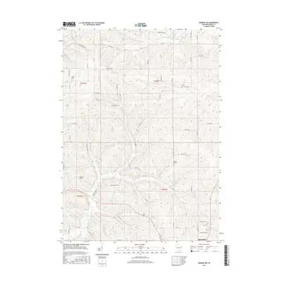
2016 Map of Monroe NW
USGS Topo · Published 2016About this map
S Br Hefty Cr and the W Br Little Sugar River define the northern drainage of this agricultural landscape in Green County. The terrain is structured by prominent ridgelines, including Dividing Ridge Rd, which separates the various creek systems that flow through the township. Family names are deeply embedded in the geography, seen in local landmarks and burial grounds such as Shooks Prairie Cem and the Benkert Cem.
Find a feature on this map
63 named features on this map. Tap any name to fly to it.
Don’t see what you’re looking for? This feature index may not catch every label — zoom into the map to look around manually.
Map Details
Editions of this 2016 Monroe NW Map
This is the sole edition of this map. No revisions or reprints were ever made.
Other maps of this area

1920 · Monroe
USGS Topo · 1:62,500

1922 · Monroe
USGS Topo · 1:62,500

1923 · Blanchardville
USGS Topo · 1:62,500

1923 · New Glarus
USGS Topo · 1:62,500

1923 · South Wayne
USGS Topo · 1:62,500

1954 · Rockford
USGS Topo · 1:250,000

1955 · Rockford
USGS Topo · 1:250,000

1958 · Rockford
USGS Topo · 1:250,000
1962 · Juda
USGS Topo · 1:24,000
1962 · New Glarus
USGS Topo · 1:62,500