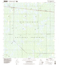
1995 Map of Monroe Station
USGS Topo · Published 1999About this map
Monroe Station and Indian Village sit along the northern edge of this map, marking human presence within the expansive Big Cypress National Preserve during the mid-1990s. The landscape is defined by the hydrologic patterns of the Everglades, where water moves slowly through cypress sloughs known as strands. These features, including Monroe Strand and Gannet Strand, create a distinct linear vegetation pattern visible even on topographic sheets.
Find a feature on this map
25 named features on this map. Tap any name to fly to it.
Don’t see what you’re looking for? This feature index may not catch every label — zoom into the map to look around manually.
Map Details
Editions of this 1995 Monroe Station Map
This is the sole edition of this map. No revisions or reprints were ever made.
Other maps of this area

1956 · Miami
USGS Topo · 1:250,000

1958 · Miami
USGS Topo · 1:250,000

1972 · Monroe Station NE
USGS Topo · 1:24,000

1972 · Lostmans Trail
USGS Topo · 1:24,000

1972 · Big Boy Lake
USGS Topo · 1:24,000

1972 · Burns Lake
USGS Topo · 1:24,000

1973 · Gator Hook Swamp
USGS Topo · 1:24,000

1973 · Fiftymile Bend
USGS Topo · 1:24,000

1973 · North Of Fiftymile Bend
USGS Topo · 1:24,000

1973 · Monroe Station
USGS Topo · 1:24,000