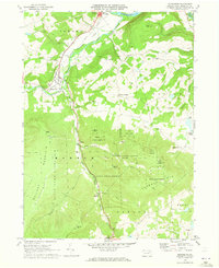
1969 Map of Monroeton
USGS Topo · Published 1973About this map
The Lehigh Valley railroad corridor defines the development of this Bradford County landscape, following the winding path of Towanda Creek and its South Branch. The settlement at Monroeton serves as a local hub near the Towanda Flats, while smaller communities like Kellogg and Liberty Corners dot the upland plateaus. For genealogists, the map identifies specific burial sites including Cole Cem and Kellogg Cem, providing precise locations for family research in the rural townships of Towanda and Asylum. Large tracts of protected land, such as State Game Lands No 36 and Tioga State Forest, dominate the southern topography, punctuated by high points like Kellogg Mountain and Robwood Mtn. The presence of several Gravel Pits and a Quarry indicates the local extractive industries supporting the area's infrastructure during the late 1960s.
Find a feature on this map
42 named features on this map. Tap any name to fly to it.
Don’t see what you’re looking for? This feature index may not catch every label — zoom into the map to look around manually.
Map Details
Editions of this 1969 Monroeton Map
4 editions found
Other maps of this area

1923 · Towanda
USGS Topo · 1:62,500

1926 · Towanda
USGS Topo · 1:62,500

1939 · Sayre
USGS Topo · 1:62,500

1942 · Sayre
USGS Topo · 1:62,500

1943 · Towanda
USGS Topo · 1:62,500

1943 · Monroeton
USGS Topo · 1:62,500

1943 · Powell
USGS Topo · 1:62,500

1945 · Powell
USGS Topo · 1:62,500

1948 · Sayre
USGS Topo · 1:62,500

1954 · Williamsport
USGS Topo · 1:250,000
Featured Places
- Wysox Township, PA
- Asylum Township, PA
- Albany Township, PA
- Kellogg, Monroe Township
- Uhdey, Asylum Township