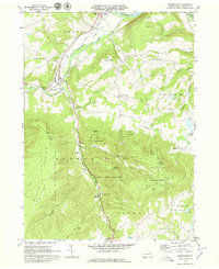
1969 Map of Monroeton
USGS Topo · Published 1979About this map
The Lehigh Valley railroad corridor and the winding course of Towanda Creek anchor this late 1960s study of Bradford County’s interior. Settlement is concentrated at the village of Monroeton, where the valley widens into the Towanda Flats, while the surrounding terrain is dominated by the steep rises of Kellogg Mountain and Hale Mtn. The map reveals a landscape heavily managed for conservation and recreation, with large tracts designated as Tioga State Forest, State Game Lands No 36, and State Game Lands No 240. For local historians, the sheet identifies rural landmarks such as the Township Sch and several family burying grounds, including Cole Cem and Kellogg Cem. The presence of a Gaging Sta near the creek and several Radio Towers atop the ridges illustrates the modern utility infrastructure integrated into this Appalachian highland.
Find a feature on this map
45 named features on this map. Tap any name to fly to it.
Don’t see what you’re looking for? This feature index may not catch every label — zoom into the map to look around manually.
Map Details
Editions of this 1969 Monroeton Map
4 editions found
Other maps of this area

1923 · Towanda
USGS Topo · 1:62,500

1926 · Towanda
USGS Topo · 1:62,500

1939 · Sayre
USGS Topo · 1:62,500

1942 · Sayre
USGS Topo · 1:62,500

1943 · Towanda
USGS Topo · 1:62,500

1943 · Monroeton
USGS Topo · 1:62,500

1943 · Powell
USGS Topo · 1:62,500

1945 · Powell
USGS Topo · 1:62,500

1948 · Sayre
USGS Topo · 1:62,500

1954 · Williamsport
USGS Topo · 1:250,000
Featured Places
- Wysox Township, PA
- Asylum Township, PA
- Albany Township, PA
- Kellogg, Monroe Township
- Uhdey, Asylum Township