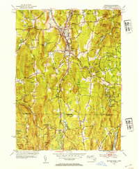
1953 Map of Monson
USGS Topo · Published 1954About this map
Monson is the central hub of this 1950s study, situated where the Central Vermont railroad tracks follow the corridor of Chicopee Brook. The map reveals a community defined by its topography, with the town center tucked between Flynt Mtn and Peaked Mtn. The surrounding landscape is heavily marked by local family and place-name history, including the Hillside Cem, Bethany Cem, and Pease Cem.
Find a feature on this map
78 named features on this map. Tap any name to fly to it.
Don’t see what you’re looking for? This feature index may not catch every label — zoom into the map to look around manually.
Map Details
Editions of this 1953 Monson Map
3 editions found

Other maps of this area

1887 · Brookfield
USGS Topo · 1:62,500

1887 · Palmer
USGS Topo · 1:62,500

1889 · Palmer
USGS Topo · 1:62,500

1890 · Brookfield
USGS Topo · 1:62,500

1892 · Woodstock
USGS Topo · 1:62,500

1892 · Tolland
USGS Topo · 1:62,500

1893 · Palmer
USGS Topo · 1:62,500

1893 · Brookfield
USGS Topo · 1:62,500

1908 · Ware
USGS Topo · 1:125,000

1915 · Brookfield
USGS Topo · 1:62,500