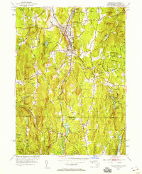
1953 Map of Monson
USGS Topo · Published 1958About this map
Chicopee Brook carves a narrow industrial and transportation corridor through the Massachusetts hill country, following the tracks of the Central Vermont railroad. In the mid-1950s, the town of Monson serves as the primary hub of this valley, flanked by several smaller clusters including North Monson and South Monson. The landscape is defined by its steep terrain, where high points like Peaked Mtn and Mount Hitchcock overlook a network of water resources such as Monson Reservoir and the Scantic River. This survey captures the borderland character of the region, specifically where Hampden and Tolland Counties meet at the state line. Large tracts of protected land, including Brimfield State Forest and Shenipsit State Forest, contrast with the localized industry of a Quarry and the small-scale settlement at Four Corners.
Find a feature on this map
59 named features on this map. Tap any name to fly to it.
Don’t see what you’re looking for? This feature index may not catch every label — zoom into the map to look around manually.
Map Details
Editions of this 1953 Monson Map
3 editions found
Other maps of this area

1887 · Brookfield
USGS Topo · 1:62,500

1887 · Palmer
USGS Topo · 1:62,500

1889 · Palmer
USGS Topo · 1:62,500

1890 · Brookfield
USGS Topo · 1:62,500

1892 · Woodstock
USGS Topo · 1:62,500

1892 · Tolland
USGS Topo · 1:62,500

1893 · Palmer
USGS Topo · 1:62,500

1893 · Brookfield
USGS Topo · 1:62,500

1908 · Ware
USGS Topo · 1:125,000

1915 · Brookfield
USGS Topo · 1:62,500