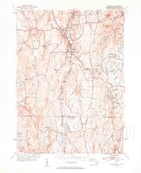
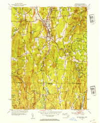
1953 Map of Monson
USGS Topo · Published 1954About this map
Chicopee Brook serves as the industrial and transit spine of this mid-century valley, carrying the Central Vermont railroad through the heart of Monson. The settlement pattern reflects a classic New England mill town layout, with North Monson and South Monson clustered along the water and rail corridor. Evidence of the local extraction economy remains visible at the Quarry near Flynt Mtn, while the upland terrain is defined by protected lands like Brimfield State Forest and the expansive Tupper Hill Wildlife Sanctuary.
Find a feature on this map
81 named features on this map. Tap any name to fly to it.
Don’t see what you’re looking for? This feature index may not catch every label — zoom into the map to look around manually.
Map Details
Editions of this 1953 Monson Map
3 editions found

Other maps of this area

1887 · Brookfield
USGS Topo · 1:62,500

1887 · Palmer
USGS Topo · 1:62,500

1889 · Palmer
USGS Topo · 1:62,500

1890 · Brookfield
USGS Topo · 1:62,500

1892 · Woodstock
USGS Topo · 1:62,500

1892 · Tolland
USGS Topo · 1:62,500

1893 · Palmer
USGS Topo · 1:62,500

1893 · Brookfield
USGS Topo · 1:62,500

1908 · Ware
USGS Topo · 1:125,000

1915 · Brookfield
USGS Topo · 1:62,500