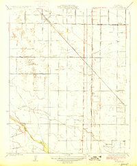
1927 Map of Monson
USGS Topo · Published 1927About this map
The Southern Pacific and Atchison Topeka And Santa Fe railroads define the transportation landscape of this Tulare County region during the mid-1920s. Small agricultural hubs like Monson and Yettem are central to the local economy, supported by an intricate network of named ditches and irrigation lines that feed the surrounding fields. The map reveals the community's social foundation through its dispersed educational institutions, including Taurusa School, Chatham School, and Elbow School. Natural waterways such as the St Johns River and Cottonwood Creek meander across the terrain, intersecting a rigid grid of rural roads like Dodge Avenue and Harlan Avenue. This survey by Kostka Mudd captures a period when the Central Valley was transitioning into a highly organized agricultural powerhouse, dictated by both rail access and reliable water management.
Find a feature on this map
21 named features on this map. Tap any name to fly to it.
Don’t see what you’re looking for? This feature index may not catch every label — zoom into the map to look around manually.
Map Details
Editions of this 1927 Monson Map
2 editions found

Other maps of this area

1921 · Stokes Mountain
USGS Topo · 1:24,000

1922 · Trimmer
USGS Topo · 1:96,000

1923 · Sultana
USGS Topo · 1:31,680

1924 · Reedley
USGS Topo · 1:31,680

1924 · Dinuba
USGS Topo · 1:125,000

1924 · Stokes Mountain
USGS Topo · 1:31,680

1926 · Goshen
USGS Topo · 1:31,680

1926 · Ivanhoe
USGS Topo · 1:31,680

1926 · Exeter
USGS Topo · 1:31,680

1927 · Traver
USGS Topo · 1:31,680