
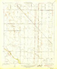
1927 Map of Monson
USGS Topo · Published 1927About this map
Cottonwood Creek and Elbow Creek meander through this agricultural landscape in Tulare County, reflecting the early 20th-century irrigation and transport networks of the San Joaquin Valley. The intersection of the Atchison Topeka and Santa Fe and the Southern Pacific railroads provided the vital backbone for local commerce, supporting small hubs like Monson and Yettem. The map reveals a community organized around rural education, with several institutions including Chatham School, Taurusa School, and Elbow School serving the surrounding farmsteads.
Find a feature on this map
19 named features on this map. Tap any name to fly to it.
Don’t see what you’re looking for? This feature index may not catch every label — zoom into the map to look around manually.
Map Details
Editions of this 1927 Monson Map
2 editions found
Other maps of this area

1921 · Stokes Mountain
USGS Topo · 1:24,000

1922 · Trimmer
USGS Topo · 1:96,000

1923 · Sultana
USGS Topo · 1:31,680

1924 · Reedley
USGS Topo · 1:31,680

1924 · Dinuba
USGS Topo · 1:125,000

1924 · Stokes Mountain
USGS Topo · 1:31,680

1926 · Goshen
USGS Topo · 1:31,680

1926 · Ivanhoe
USGS Topo · 1:31,680

1926 · Exeter
USGS Topo · 1:31,680

1927 · Traver
USGS Topo · 1:31,680