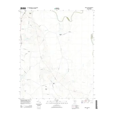
2014 Map of Mont Clare
USGS Topo · Published 2014About this map
Society Hill and the winding course of the Great Pee Dee River anchor this South Carolina landscape, which transitions from the river's alluvial plains into the upland ridges of Darlington and Marlboro counties. The river corridor is defined by deep bends and landmarks like Cockers Falls and Williams Lake, while the interior terrain is marked by distinctive geographical features such as Devils Woodyard Bay. This area has long been shaped by its agricultural and river-dependent economy, evidenced by the network of local routes like Roblyns Neck Rd and Mechanicsville Hwy.
Find a feature on this map
42 named features on this map. Tap any name to fly to it.
Don’t see what you’re looking for? This feature index may not catch every label — zoom into the map to look around manually.
Map Details
Editions of this 2014 Mont Clare Map
This is the sole edition of this map. No revisions or reprints were ever made.
Other maps of this area

1942 · Rockingham
USGS Topo · 1:125,000

1943 · Gum Swamp
USGS Topo · 1:62,500

1953 · Florence
USGS Topo · 1:250,000

1954 · Florence
USGS Topo · 1:250,000

1963 · Dovesville
USGS Topo · 1:24,000

1963 · Mont Clare
USGS Topo · 1:24,000

1963 · Darlington East
USGS Topo · 1:24,000

1963 · Darlington West
USGS Topo · 1:24,000

1971 · Society Hill
USGS Topo · 1:24,000
1972 · Cash
USGS Topo · 1:24,000